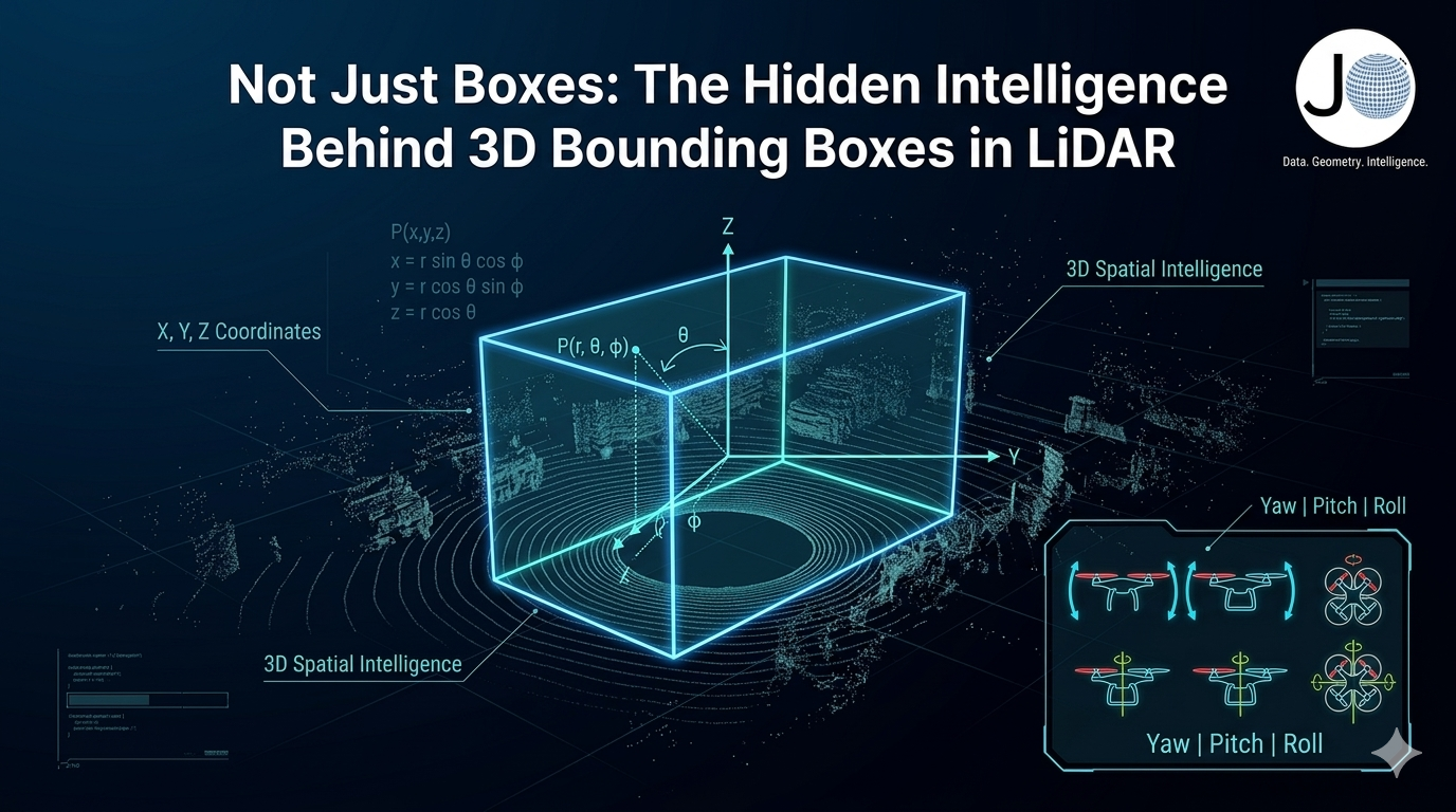
JTheta.ai

Medical Image Annotation: Powering the future of AI in Healthcare

Introduction
Medical image annotation is one of the most critical building blocks in healthcare AI. By labeling X-rays, CT scans, MRIs, and pathology slides, we create training datasets that help AI models detect diseases, predict outcomes, and assist doctors with faster, more accurate decision-making.

🔹 Uses of Medical Image Annotation

Early Disease Detection

Annotated scans help AI models recognize early signs of pneumonia, lung cancer, fractures, and other critical conditions.

Tumor Segmentation & Treatment Planning

By marking tumor boundaries in MRI or CT scans, annotations guide oncologists in radiation therapy and surgery planning.

Organ and Tissue Mapping

Accurate delineation of organs supports 3D reconstructions for surgical simulations and robotic-assisted procedures.

Pathology & Cell Analysis

Annotating cells and tissues in microscopic slides helps AI models detect anomalies like abnormal cell growth.

Medical Research & Drug Development

Annotated datasets enable researchers to understand disease progression and evaluate drug responses more effectively.

Guide to LiDAR Annotation: Building 3D Datasets for Autonomous Systems, Robotics, and Smart Cities

Introduction
LiDAR (Light Detection and Ranging) produces 3D point clouds that capture the world in incredible detail. From autonomous vehicles to smart cities, LiDAR annotation is critical for teaching AI how to understand depth, distance, and object shape.

🔹 Uses of LiDAR Annotation

Autonomous Driving

Annotating vehicles, pedestrians, cyclists, and traffic signs in 3D point clouds.

Smart Cities & Infrastructure

Mapping buildings, roads, and utilities for urban planning.

Robotics & Drones

Training robots and UAVs to navigate using 3D environmental understanding.

Forestry & Environmental Monitoring

Identifying tree heights, forest density, and terrain modeling.

Construction & Mining

Site surveying, volume measurement, and safety monitoring.

Satellite Image Annotation

Introduction
Satellite imagery captures massive amounts of data every day — from tracking deforestation to monitoring urban growth. But raw images alone don’t provide insights. That’s where satellite image annotation comes in. By labeling objects, land types, and regions of interest, we create datasets that fuel AI models for agriculture, climate science, defense, and disaster management.

🔹 Uses of Satellite Image Annotation

Land Use & Land Cover Classification

Annotating forests, water bodies, urban areas, and farmland for environmental monitoring.

Agriculture & Crop Monitoring

Identifying crop health, field boundaries, and yield predictions to help farmers make data-driven decisions.

Disaster Response & Risk Management

Labeling flood zones, wildfire areas, or landslides for rapid disaster assessment.

Urban Planning & Smart Cities

Annotating roads, buildings, and infrastructure to support city planning and traffic optimization.

Defense & Surveillance

Detecting vehicles, ships, or structures for national security and geospatial intelligence.

End to End Data Annotation Workflow

Introduction
High-quality AI depends on high-quality annotated data. But how does raw data turn into structured, labeled datasets ready for machine learning? At [Your Company Name], we provide a seamless end-to-end annotation workflow — from project creation with datasets to final export.

Here’s how it works:

🔹 Step 1: Create a Project & Add Your Dataset

The workflow begins by creating a new annotation project.

Upload or link your dataset directly within the project setup.

Add multiple datasets if needed for comparison or multi-source training.

Ensure secure and organized dataset management right from the start.

🔹 Step 2: Define Classes & Annotation Types

During project creation, you can also set up the annotation schema:

Define class labels (e.g., Car, Person, Building, Tumor).

Choose annotation types such as bounding boxes, polygons, keypoints, or segmentation masks.

Standardizing classes at this stage ensures annotation consistency.

🔹 Step 3: Assign Annotators & Reviewers

Once the project is ready, tasks are distributed:

Annotators label the images or scans.

Reviewers validate annotations for quality.

Role-based workflows ensure accountability and collaboration.

🔹 Step 4: Annotate with AI-Assist + Human Precision

This is where the real annotation happens:

AI-Assist tools pre-label objects, speeding up repetitive tasks.

Annotators refine results with manual adjustments for accuracy.

Works across all domains: medical scans, satellite images, LiDAR point clouds, and general images.